07/17/2018
The Lime Hollow Nature Center located just a few miles from the SUNY Cortland campus features 430 acres of woods and wetlands.
Local residents frequent it as a respite, to hike the trails and connect with nature.
That area, however, hasn’t always been so serene. It was home to a bustling lumber mill and many farmsteads over the past few centuries.
This summer, one busy SUNY Cortland student is trying to find out exactly what took place where on the grounds.
Senior geographic information systems major Devyn Tremblay is one of 10 SUNY Cortland students who received a 2018 undergraduate summer research fellowship. He’s working with History Department faculty mentor Scott Moranda in digitally mapping and uncovering the history of Lime Hollow.
Tremblay, from Helmetta, N.J., is minoring in computer applications and has a concentration in advanced geospatial applications. During his sophomore year, he worked with Scott Anderson, professor in the Geography Department, to chart a small section of the nature center.
“We came out here and mapped a few of the old ponds and dikes and dams for the lumber mill,” Tremblay said. “From there, the idea expanded. Now we’re going to do the entire property.”
The Lime Hollow Nature Center is a private, 501(c)3 not-for-profit that is celebrating its 25th anniversary in 2018. It offers year-round recreation opportunities as well as summer camps for children and a variety of educational events.

Moranda, associate professor of history, has helped Tremblay sift through approximately 200 years of property deeds for the area from the Cortland County database. Tremblay’s ultimate goal is to create a video using GIS software that shows the changing ownership and usage of the land in each parcel of the 430-acre nature center.
The scope of this research is much more intense than the work Tremblay did two years ago.
“This is entirely different,” he said. “That was one tiny little piece in a 500-piece puzzle. And that’s what it is, it’s a puzzle. We’ll sit there in the lab trying to figure out one piece of it for hours.”
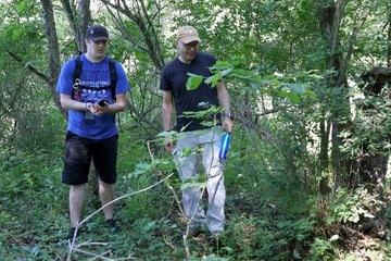
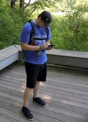
First, Tremblay and Moranda will walk through Lime Hollow searching for stone walls, tree walls or surveyors’ corners that may indicate an old property line. Tremblay will mark the coordinates on his Trimble GPS unit and then he will search through the archived deeds for a match.
It isn’t always that easy. Some of the deeds lack coordinates or accurate measurements. Others make reference to natural landmarks that are long since gone. Tremblay was particularly frustrated by one record that indicated a property line began at “an elm tree in the middle of the highway.” That didn’t serve as much of a clue in 2018.
Not only is Tremblay mapping what pieces of land belonged to certain people at a given time, he and Moranda are also consulting cultural censuses from the 19th century that shed light on the types of crops farmers were growing. The ecology of the area is ever-changing. For example, about 100 years ago, very little of the Lime Hollow area was forested.
“Maybe there’s a young maple forest there now, but we will be able to say that this area was pasture in 1880 or that was a farm that grew corn,” Moranda said.
The economic history of the people who lived around Lime Hollow is depicted in the data as well. Certain time periods, say 1929-30, show a volatile shift in land ownership, as would be expected at the breakout of the Great Depression. Other periods have left Tremblay scrambling to find more hints in the County’s historical archives.

“There have been a lot of interesting transactions between properties that you wouldn’t expect,” Tremblay said. “There is a single creamery and a wood mill where you can trace back the property to the early 1850s. At one point it was owned by eight different people in five years. You never expect something like that. The puzzle changes.”
Tremblay plans to present his research at the New York State Geospatial Summit, which will be held in Skaneateles, N.Y. in September. He’ll also share his findings at SUNY Cortland’s annual “Transformations: A Student Research and Creativity Conference” in the spring of 2019.
Moranda, whose specialties are German history and environmental history, has a long-term goal of creating a mobile application and a website to host digital mapping projects such as Tremblay’s. Since their findings have such a wide range of academic interest, from economics to biology and everything in between, this data may be useful to others for decades to come.
“Once Devyn creates this map, this ends up being a research tool for other scholars,” Moranda said. “If you’re interested in economic history and land ownership, they could use this as a tool to trace that. Or if they’re biologists and they want to know the historic ecology, this could be helpful.”
The undergraduate summer research fellowships were created in 2007 to offer students and faculty mentors to engage in eight weeks of full-time scholarly activity during the summer. The fellowships are student-designed and include a modest stipend and up to eight weeks of on-campus housing.
This year’s 10 summer research fellows are studying a range of subjects from biological sciences to psychology to political science.
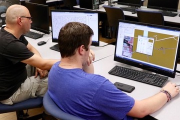
Tremblay has thrived this summer, racing back and forth between mapping points at Lime Hollow and inputting the data on a computer in the Geography Department lab in Old Main.
“One skill he’s learning is patience,” laughed Moranda. “But he’s also learning puzzle-solving.”
“And puzzle making,” added Tremblay.
This experience has helped solidify Tremblay’s decision to pursue his academic passion in graduate school.
“A master’s degree will allow me to continue historical GIS and work within archeological dig sites as well as other forms of ancient or even more modern, such as 19th or 20th century, historical geography,” he said. “It’s tedious but it’s fun.”